Marks of Time
Historic Buildings as  illustrations of the past.
  • Home
  • Blog
    • Derry to Strabane
    • Derry to Limavady
    • Kilkenny to Derry
    • Dublin Visit
    • Inishowen Tour
    • Co Down Visit
    • Carrickfergus Tour
    • Stirling
    • Belfast to Derry
  • About
    • Links
    • Further Reading
  • Contact
  • Map Viewer
  • Counties

November 30th, 2017

30/11/2017

0 Comments

 
Picture
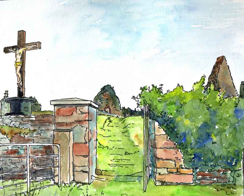
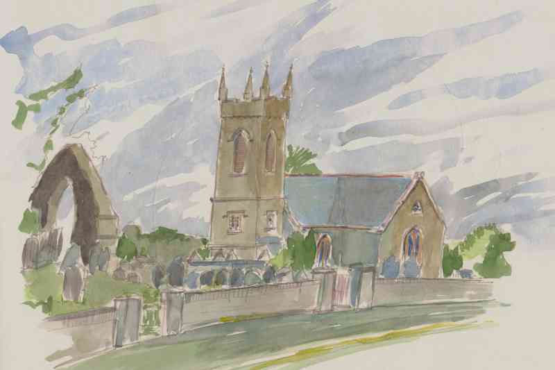
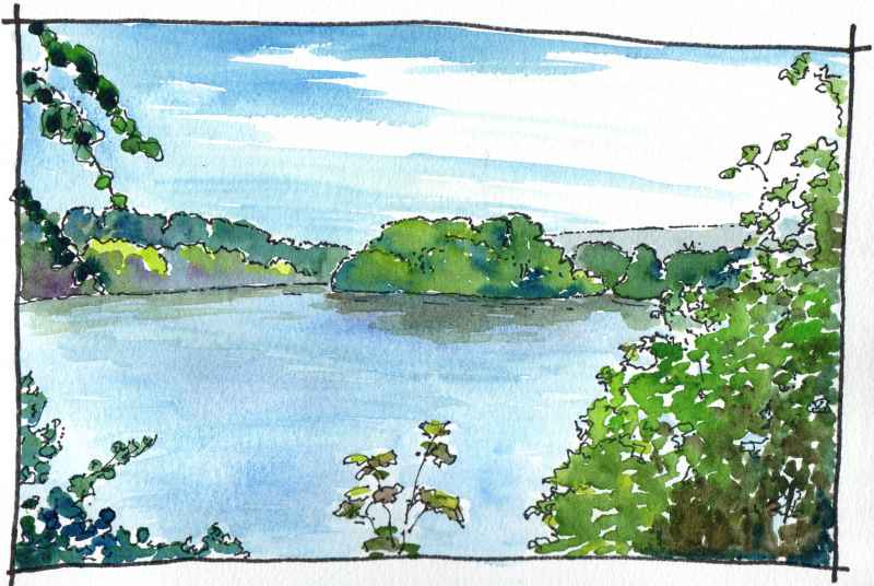
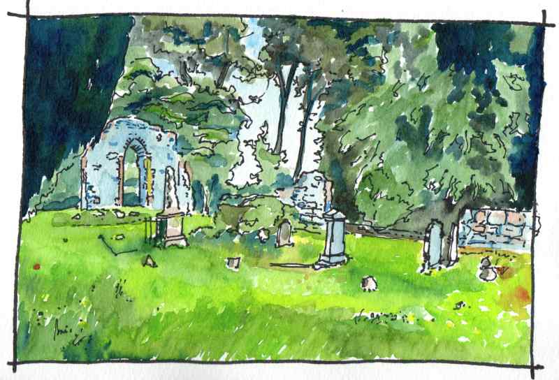
Faughanvale Old Chuch is sited above the road near the village of Greysteel. Hidden from view  near a bend in a steep road it is in a very picuresque location with fine views over Lough Foyle.  Reputedly the site of a 7th century monastery associated with St Canice..
0 Comments

November 28th, 2017

28/11/2017

0 Comments

 
Picture

Some remnants of the WWII airfield remain, such as this ‘blister’ type aircraft hangar, one of a group of three to the north west side of the airfield. It and the airfield were constructed by the Royal Engineers over the winter of 1940-41.The type had standardised prefabricated components and it was designed to be quickly erected and dismantled.  This example, however, has now lasted in the one place for 77 years.
0 Comments

531.

27/11/2017

0 Comments

 
Picture


Back to Clooney Road, City of Derry Airport is located beside the road on another former WWII airfield. This was RAF Eglinton air base home to No. 133 Squadron RAF from 1941 which flew Hurricane fighters. In 1943 the airfield became a Fleet Air Arm base called RNAS Eglinton and was home to the No. 1847 Fleet Air Arm Squadron  providing convoy cover as part of the Battle of the Atlantic. In 1978 the airfied was purchased by the district council and the current terminal was erected as part of a significant investment with European Regional Development support and opened in 1993. Designed by WRD and RT Taggart architects it is a bright welcoming building designed for ease of internal adaptability and extension. While significant extensions have not been required the subdivision of the internal space has undergone a number of changes during subsequent years. An open an airy interior has largely been retained however.

0 Comments

November 21st, 2017

21/11/2017

0 Comments

 
Picture

At the far end of the village is a remnant from plantation times. This is the surviving gable of its original church dating from 1826. On the opposite side of the road under the peresent rectory was the ‘castle’. This was beseiged in 1641 and  its ruins demolished in the renovation and enhancement of the village by the Grocers Company in the 1820′s. The current parish church behind was another symtom of this change it was  funded by the company and constructed in 1821.
0 Comments

529.

20/11/2017

0 Comments

 
Picture
At the next roundabout turn right to what is sign posted as the ‘plantation village of Eglinton’.  This is dominated by its former courthouse, standing opposite the access road to the village which is now used as a credit union.  This was built in the 1820’s and held a petty sessions court on the first floor and a market space  among open arcades on the ground floor with a medical dispensary to the rear. The buildings real use, however,  was an important architectural set piece at the heart of the village signifying the taste and sophistication of the Grocer’s Company of London. Though they had been granted the surrounding area by King James I in the Seventeenth Century, as part of the Ulster Plantation, they had leased the land to agents until the lease came up again upon the death of George III in 1820. They, like many of the other London Companies with lands in the county,  then took direct control and a period of architectural competion ensued with direct investment in villages like Eglinton, Ballykelly, Draperstown, Moneymore, and Kilrea. As part of the plan, in this village, two complementary buildings were built on either side of this focus. The Manor House to the left remains in fine condition. The Glen House to the right has unfortunately been heavily renovated, following a period of use as a hotel, and has lost much of its character. The court house has been recently well conserved and is well worth a visit. On the wall to one side is the arms of the Grocer’s Company who gave up their involvement with the village following the land reforms of the 1890′s. 
0 Comments

November 16th, 2017

16/11/2017

0 Comments

 
Picture
Further along Clooney Road opposite the turn off to Campsie Industrial Estate is this unusual structure half embedded in the hillside. This is also a remnant of the Second World War. It is an operations room  for anit aircraft operational comand in the area. Built between 1941 and 1944 it is one of only two examples of this type of structure built in Northern Ireland. The other example was at Thiepval Barracks in Lisburn. it is actually two stories  high and contains a large double height operations room. The projection on the roof is a ventillator.              
0 Comments

November 15th, 2017

15/11/2017

0 Comments

 
Picture
Next on Clooney Road is Maydown Roundabout, to the left is an industrial estate constructed on top of a former military airfield which extends into the nearby Du Pont factory complex. Maydown Airfield operated from 1941 to 1947 and like all of the airfields along this coast, the job of those stationed here was to guard the convoys through the Western Approaches in the Battle of the Atlantic and to destroy hostile enemy ships and submarines. From 1941 to 1942 it was a satelite to nearby R.A.F. Eglinton.  It was a USAAF airfield for a period in 1942 transfering to Royal Naval command in 1943, when it became known as  RNAS Maydown  and HMS Shrike. The drawing above is a copy of a photograph from c1944 when Fairy Swordfish  were stationed at the site. A nice mild Lough Foyle day it was too! Today, remnants of the runways can still be seen, though all associated buildings are gone.
0 Comments

526.

14/11/2017

0 Comments

 
Picture

There are two lakes at Enagh and beyond the westernmost is a glade of tall trees. It is one of my favourite places at this time of year. Together, the trees create a tall  space of great  bueaty. The narrow glade is indicated on the first Ordnance Survey map of 1832.  About half a mile away to the right is the location of another medieval church - Dergbruagh Church. Interestingly, the  Tower house in the eastern lough, Engah Church, and  the site of Dergbruagh all aline. Two churches so close together is also unusual.  Best way to get to the glade to soak up the atmosphere is through the grounds of Gransha hospital.
0 Comments

525.

13/11/2017

0 Comments

 
Picture
Visible from the medieval church, this crannog or artifical island in Enagh Lough is known as ‘Rough Island’ or ‘O’Cahan’s Garden’. Excavation has shown that it is partly a natural island but that it has been modified by humans from the Bronze Age onwards. It was occupied by the O’Cahan’s in the medieval period and, like most, would have had a timber palisade defending  timber buildings inside.  Behind the island, blending into the trees, is a second crannog - ‘Green Island’ which is now connected to the shore by a causeway. This was the location of an O’Cahan tower house which was occupied until the seventeenth century. Its ruins were demolished in the mid nineteenth century
0 Comments

November 10th, 2017

10/11/2017

0 Comments

 
Picture
Next left turn leads to Enagh Church. It is a hugely atmosperic place situated between two small ‘loughs’. The date of the current runs are unknown but its east window probably dates to  rebuilding in the seventeenth century. It was assocated with the O’Cahans in the middle ages who had a tower house on a nearby Crannog and is is thought to be the site of a much older ecclesiastical centre, which may have been founded by Saint Canice, Bishop of Aghaboe and patron saint of Kiannachta, who died in the sixth century.Other sources suggest Colum Crag or Columba may have founded the  church, This church is known to have been one of three that were plundered in 1197 by an Anglo-Norman raiding party.It is thought to have been a monastic site, later converted into a parish church. Why not visit and soak up the atmosphere?
0 Comments
<<Previous

    Marks of Time

    Sketches of buildings in the North West of Ireland and further afield with a little information about their history.

    Search the Categories below for specific places .

    Go to the archives to follow the exploration from 2015

    Go to the  drop down to follow some of the routes explored.

    Categories

    All
    Co Antrim
    Co Armagh
    Co Carlow
    Co Cavan
    Co Clare
    Co Cork
    Co Derry / Co Londonderry
    Co Donegal
    Co Down
    Co Dublin
    Co Fermanagh
    Co Galway
    Co Kilkenny
    Co Limerick
    Co Longford
    Co Louth
    Co Mayo
    Co Meath
    Co Monaghan
    Co Offaly
    Co Roscommon
    Co Tipperary
    Co Tyrone
    Co Waterford
    Co Westmeath
    Co Wexford
    Co Wicklow
    Derry~Londonderry
    England - Bristol
    England - Carlisle
    England - Chester
    England - Liverpool
    England - London
    England - Nottingham
    England - Swindon
    England - Wirral
    France - Brittany
    France - Dordogne
    France - Picardy
    I Belgium - Louven
    I Belgium - Ypres
    I Netherlands - Amsterdam
    I Scotland - Argyllshire
    I Scotland - Drumfries
    I Scotland - Dunblane
    I Scotland - Glasgow
    I Scotland - Perthshire
    I Scotland - Stirling
    I Scotland - Stranraer
    I Scotland - Trossachs
    I Ukraine
    I US - New York
    I Us - San Francisco
    I Us - San Francisco
    I US - Seattle
    I Wales - Caernarvonshire
    I Wales Denbighshire
    I Wales Flintshire
    Local - Ardstraw
    Local - Armagh City
    Local - Ballycastle
    Local - Ballykelly
    Local - Baronscourt
    Local - Belfast
    Local - Buncrana
    Local - Burt
    Local - Carndonagh
    Local - Carrickfergus
    Local - Castlebar
    Local - Clady
    Local - Clonmacnoise
    Local Clonmany
    Local - Clonmany
    Local - Coleraine
    Local - Culdaff
    Local - Donegal Town
    Local - Donemana
    Local - Drumsurn
    Local - Dublin
    Local Dungiven
    Local - Dungiven
    Local - Eglinton
    Local - Galway City
    Local - Glenelly Valley
    Local - Gortin
    Local - Greysteel
    Local - Kilkenny
    Local - Kilmore
    Local - Leckpatrick
    Local - Lifford
    Local - Limavady
    Local - Maghera
    Local - Magilligan
    Local - Moville
    Local - Newtonstewart
    Local - Sion Mills
    Local - Strabane
    Local - Tramore
    Local - Waterford City
    Local - Westport
    World Heritage Sites

    Archives

    January 2023
    November 2022
    October 2022
    September 2022
    June 2022
    May 2022
    April 2022
    March 2022
    February 2022
    January 2022
    December 2021
    October 2021
    August 2021
    July 2021
    June 2021
    April 2021
    March 2021
    February 2021
    January 2021
    December 2020
    August 2020
    June 2020
    May 2020
    April 2020
    March 2020
    February 2020
    January 2020
    December 2019
    November 2019
    October 2019
    September 2019
    August 2019
    July 2019
    June 2019
    May 2019
    April 2019
    March 2019
    February 2019
    January 2019
    December 2018
    November 2018
    October 2018
    September 2018
    July 2018
    June 2018
    May 2018
    April 2018
    March 2018
    February 2018
    January 2018
    December 2017
    November 2017
    October 2017
    September 2017
    July 2017
    June 2017
    May 2017
    April 2017
    March 2017
    February 2017
    January 2017
    December 2016
    November 2016
    October 2016
    September 2016
    August 2016
    July 2016
    June 2016
    May 2016
    April 2016
    March 2016
    February 2016
    January 2016
    December 2015
    November 2015
    October 2015
    September 2015
    August 2015
    July 2015
    June 2015
    May 2015
    April 2015
    March 2015
    February 2015
    January 2015

    RSS Feed

Powered by Create your own unique website with customizable templates.