Marks of Time
Historic Buildings as  illustrations of the past.
  • Home
  • Derry Londonderry
    • The Early City
    • New World Order: The Arrival of the English
    • The Merchant City: The Eighteenth Century
    • The Industrial City: The Nineteenth Century
    • The Troubled City: The Twentieth Century
    • The Creative City: The Twenty-First Century
  • Ulster
    • The Early Region
    • Early Christian
    • Hiberno Romanesque
    • The Anglo Normans
    • Tower Houses and Friaries
    • The Plantation
    • The Georgians
    • Vernacular
    • The Victorians
    • Early Twentieth Century
    • The Twentieth Century
    • The Twenty First Century
  • Strabane
    • The Early Region Strabane
    • Early Christian Strabane
    • Norman Strabane
    • Plantation Strabane
    • A New Order
    • Vernacular Strabane
    • Georgian Strabane
    • The Strabane Canal
    • Arcadian Living Strabane
    • Early Nineteenth Century Strabane
    • Strabane Railway
    • Strabane Industry - Sion Mills
    • Late Nineteenth Century Strabane
    • Early Twentieth Century Strabane
    • Twentieth Century Strabane
    • Twenty First Century Strabane
  • Blog
    • Derry to Strabane
    • Derry to Limavady
    • Kilkenny to Derry
    • Dublin Visit
    • Inishowen Tour
    • Co Down Visit
    • Carrickfergus Tour
    • Stirling
    • Belfast to Derry
  • About
    • Links
    • Further Reading
  • Contact

March 09th, 2018

9/3/2018

0 Comments

 
Picture

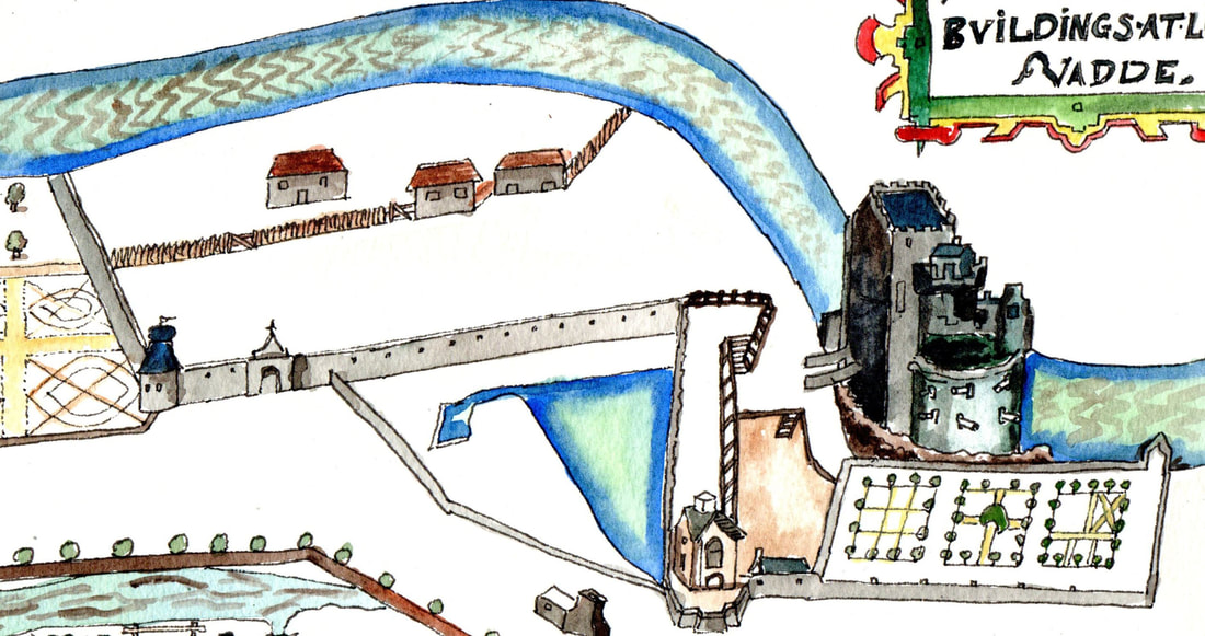
Further along the Roe was O’Cahan’s Castle. This drawing is a sketch of the castle and its grounds as indicated on a map of 1622.  The O’Cahan’s held  this area from the Twelfth Century until the Seventeenth with a break in the Thirteenth  when the Anglo-Normans were in  control. The castle, like most tower houses, was probably built in the Fifteenth Century. In 1610, as part of the Plantation of Ulster, it and 13,100 acres were granted to Sir Thomas Phillips a ‘soldier of fortune’ in exchange for reliquishing his control of Coleraine. Like contemporaies at Dungiven, Enniskillen and Donegal, he set about renovating and expanding the castle and he comissioned the map of 1622. There are reports of fine plasterwork inside but the drawing shows a heavily defended tower. It also shows formal gardens and what has been interpreted as a fish pond and brewery building.  A slated house with a  large window overlooks the fish pond.  There are also buildings for agricultural workers.The Ordnance Survey Memoirs of the 1830′s record that the old castle was demolished in the 1820′s.

0 Comments


Leave a Reply.

Powered by Create your own unique website with customizable templates.