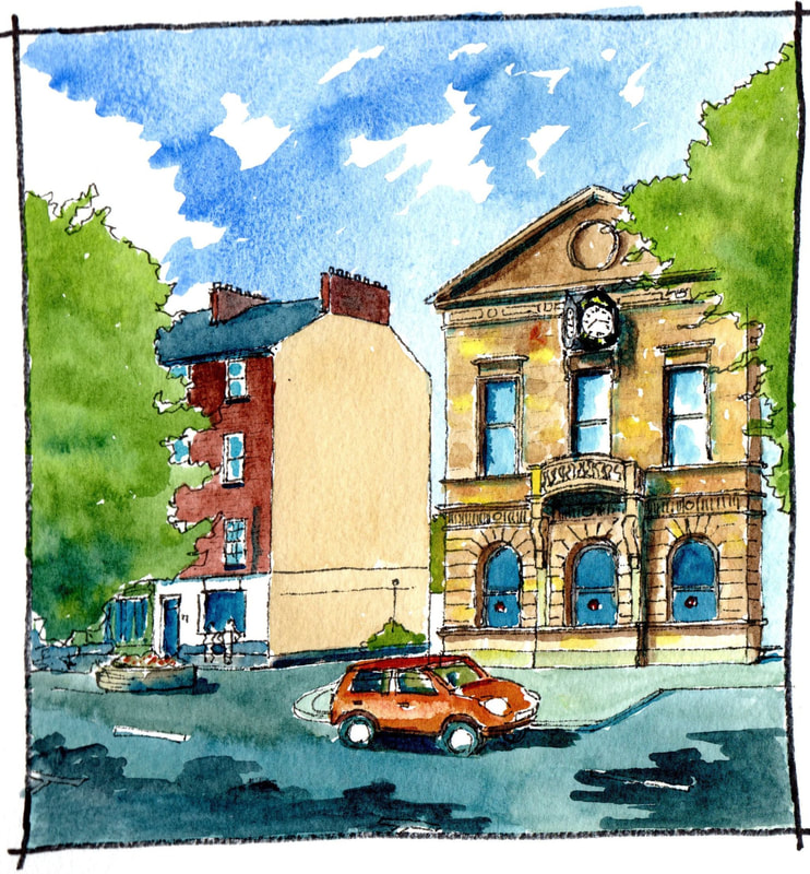
The facade of the Alexander Memorial Hall, half way down the street, dates from the mid nineteenth century, but its classical style perfectly complements the neighbouring Georgian buildings. The rest of the building has been replaced by a modern arts centre, but the regular spacing of trees ensures that it is hard to see both as a single building. Instead, the facade remains an important remnant that brings its own presence to the street.
0 Comments
Limivady Main Street has a number of tall brick houses in the Georgian Style. These are thought to date from the late eighteenth century. A number of those to the western side of the street, such as the Alexander Arms, have double pile roofs, that is, is a central gutter joining two pitched roofs. These were probably built earlier in the century. The two shown here have a single pile roof enclosing a longer span and are probably from later in the century. Brick making was once a major local industry with ‘brick fields’ noted in many locations on the 1830 map. The effect of these buildings was to create an elegant space which was remarked upon by travellers. This effect was complemeted by trees planted at regular intervals At the other end of Limavady Main Street, also within a garden well back from the building line, is Christ Church. This modest looking building is quite decorative inside and well worth a visit. A church is recorded here from the late seventeenth century and the present building was constructed in 1750. The tower was added in 1765. It is a haven of calm away from the main street. In recent years a new bypass has revealed a dramatic view of the building from the opposite side. From there it is revealed as located on a high platform comanding the plain beyond. Tucked away at the southern end of Main Street in Limavady is this important building. Indicated on a 1699 map as ‘New Hall’ it was occupied at that time by George Philips grandson of the original lessor of the Limavady Estate at the time of the Ulster Plantation. The building today is Georgian in style suggesting construction in the eighteenth century. Records show that in 1742 New Hall was leased to Thomas Smith of Limavady after he had spent “£300 on building the house and improving the office houses”. It sounds like a substantial rebuild. Until 1900, however, the entrance gates of the building terminated the view down Main Street helping to emphasise its former importance. In that year part of the garden was sold off to allow construction of the Masonic Hall.
This is a copy of the first map of Limavady from 1622. It was a new Ulster Plantation settlement replacing the former town a mile away around the old O’Cahan Castle. Originally known as Newtown Limavady, the settlement had a cruciform layout with a market cross at the centre and was enclosed on two sides, as today, by the River Roe. The building nearest the river appears to have a projecting sign which has been taken by most comentators to be the representation of an Inn..
North Watch Tower Roe Valley Country Park. This is one of two towers built to guard the nearby bleach green which was opened in 1766 by Lesley Alexander and closed in 1831. Such greens were an important part of Linen making, with sheets laid out to bleach in the sunlight. As a valuable commodity they had to be protected from thieves and hence the watch towers. Such buildings, once common are now very rare. The two in the country park are among the best examples surviving. This one, along a public path was, however, rebuilt as a faithful replica from its foundations in the mid 1970′s.
Slighly downstream from the powerhouse is this ruined mill built into precipitous side rocks of the River Roe. Rubble stone in its lower storey and brick to first floor it appears fairly typical of the ruined mills in the modern country park. However, there have been suggestions that this structure may be on the location of, or may partly date from, the Anglo Norman occupation of the area in the Twelfth Century. Two mills of the ‘Roo' were recorded in an inquisition of 1333 at the time of the death of Richard de Burgo The Red Earl of Ulster. The building is marked on the first Ordnance Survey Map of the area of 1831. By 1848 it is labelled ‘Old beetling mill’ and indicated as roofless by 1907. It is likely that it was used for a number of functions during its history, as a corn mill, and as a beetling mill associated with the Linen Industry. Today it is located in a quiet corner of the park and is a great dramatic ruin Dog Leap Power House, Roe Valley Country Park. Further up the river is this modest building with a curved corner. It was constructed in the 1890′s by the owner of Roe Park House:J T Ritter. Installing water turbines, he generated the first electricty in this area and powered both his house and, from 1904, the nearby town of Limavady. His company was aquired by the Electricity Board for Northern Ireland in 1946 and finally closed in 1967. Now a listed building it was sentively restored by the Northern Ireland Environment Agency in 2014 to generate electricty once again - green energy!
O’Cahan’s castle today is a circular grassy clearing within the surrounding forest of the Roe Valley Country Park. The strongly defensive nature of the site can still be understood by the height of the platform above the river and the steeply sloping ground down to it. A three storey tower house above this must have looked very impressive. Limited archaeological investigations were carried out in 2009 after Geophysical anomalies had suggested the survival of portions of the associated bawn and fishpond. Modern fill was found covering much of the area investigated, but the corner of the castle was identified with bedrock shored up to take this, and fragments of glass and pottery. You can read more at: www.excavations.ie/report/2009/Derry/0020515/ Further along the Roe was O’Cahan’s Castle. This drawing is a sketch of the castle and its grounds as indicated on a map of 1622. The O’Cahan’s held this area from the Twelfth Century until the Seventeenth with a break in the Thirteenth when the Anglo-Normans were in control. The castle, like most tower houses, was probably built in the Fifteenth Century. In 1610, as part of the Plantation of Ulster, it and 13,100 acres were granted to Sir Thomas Phillips a ‘soldier of fortune’ in exchange for reliquishing his control of Coleraine. Like contemporaies at Dungiven, Enniskillen and Donegal, he set about renovating and expanding the castle and he comissioned the map of 1622. There are reports of fine plasterwork inside but the drawing shows a heavily defended tower. It also shows formal gardens and what has been interpreted as a fish pond and brewery building. A slated house with a large window overlooks the fish pond. There are also buildings for agricultural workers.The Ordnance Survey Memoirs of the 1830′s record that the old castle was demolished in the 1820′s.
|
Marks of Time
Sketches of buildings in the North West of Ireland and further afield with a little information about their history. Categories
All
Archives
April 2024
|