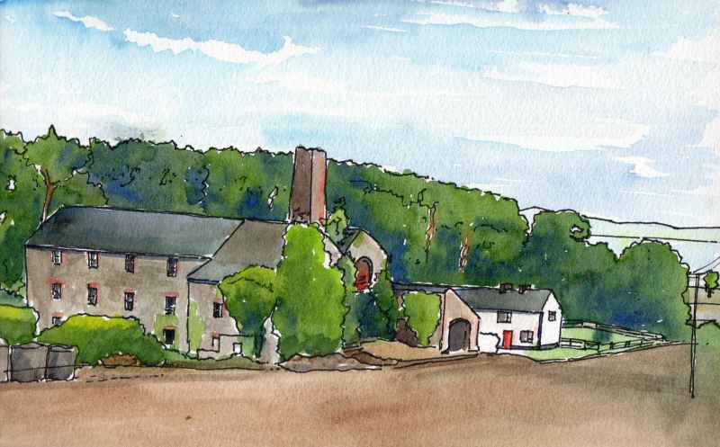
Carrickhugh Flour Mill sits below Clooney Road with fine views accross Lough Foyle. Today it is a big empty shed used for farm machinery but at one time it was a thriving mill located at the base of a stream to get water power. However, the Ordnance Survey Memoirs of 1830-35 explained that ‘As the supply of water is not good in dry weather, the deficiency has been remedied by a steam engine of 12 horse-power which commenced working a few days since.’ This explains the chimney. The mill continued in operation for various uses until after the Second World War, (when it was used for corn grinding). It was converted to farm use after 1948. Today it is an important and visible reminder of the many former mills in this area, which were once a significant source of employment
Next the ‘plantation village of Eglinton’. This is dominated by its former courthouse, standing opposite the access road to the village which is now used as a credit union. This was built in the 1820’s and held a petty sessions court on the first floor and a market space among open arcades on the ground floor with a medical dispensary to the rear. The buildings real use, however, was an important architectural set piece at the heart of the village signifying the taste and sophistication of the Grocer’s Company of London. Though they had been granted the surrounding area by King James I in the Seventeenth Century, as part of the Ulster Plantation, they had leased the land to agents until the lease came up again upon the death of George III in 1820. They, like many of the other London Companies with lands in the county, then took direct control and a period of architectural competion ensued with direct investment in villages like Eglinton, Ballykelly, Draperstown, Moneymore, and Kilrea. As part of the plan, in this village, two complementary buildings were built on either side of this focus. The Manor House to the left remains in fine condition. The Glen House to the right has unfortunately been heavily renovated, following a period of use as a hotel, and has lost much of its character. The court house has been recently well conserved and is well worth a visit. On the wall to one side is the arms of the Grocer’s Company who gave up their involvement with the village following the land reforms of the 1890′s.
City of Derry Airport is located beside the road on another former WWII airfield. This was RAF Eglinton air base home to No. 133 Squadron RAF from 1941 which flew Hurricane fighters. In 1943 the airfield became a Fleet Air Arm base called RNAS Eglinton and was home to the No. 1847 Fleet Air Arm Squadron providing convoy cover as part of the Battle of the Atlantic. In 1978 the airfied was purchased by the district council and the current terminal was erected as part of a significant investment with European Regional Development support and opened in 1993. Designed by WRD and RT Taggart architects it is a bright welcoming building designed for ease of internal adaptability and extension. While significant extensions have not been required the subdivision of the internal space has undergone a number of changes during subsequent years. An open an airy interior has largely been retained however.
Further along Clooney Road opposite the turn off to Campsie Industrial Estate is this unusual structure half embedded in the hillside. This is also a remnant of the Second World War. It is an operations room for anit aircraft operational comand in the area. Built between 1941 and 1944 it is one of only two examples of this type of structure built in Northern Ireland. The other example was at Thiepval Barracks in Lisburn. it is actually two stories high and contains a large double height operations room. The projection on the roof is a ventillator.
Heading south west along the Clooney Road you will pass these two buildings. These are the gate lodges to Gransha Mental Hospital. Constructed in the 1960′s, they have copper roofs and off centre windows symetrical about the entrance road. To the front a low wall of Claudy stone raised to a higher level as it meets the road. Beyond, iquite far away in landscaped grounds, stood Stradreagh House the Victorian building used as the Asylum. Various other buildings dating to the 1930′s and later were built in between. It is a simple but elegant architectural composition beside the main road.
We end at Clooney church. Located in the grounds of St Columb’s Park in the Waterside area of Derry~Londonderry not far from the Limavady Road (which is renamed Clooney Road as it leaves the city). The church today looks much as drawn on the first map of the city drafted by the invading English in 1600. It is ruinous, on top of a small hill and retains its gables. In fact, the building was rebuilt in the 1620′s and has since fallen into ruin again. It is thought to have been previously rebuilt in the 1580′s following the demolition of the previous church in the 1480′s by the local Bishop. The building is recorded as having been plundered by the Normans in the 1190′s and is thought to be the site of the ancient church of ‘Cluain-i’. It is associated with St Brecan -an early Irish saint thought to be from Movilla in Co Down with a feast day of 16 July. In the nineteenth century it became an eye catcher within the landscaped grounds of a merchant’s house and today is located within a civic park. It is an atmospheric place, timeless in its bueaty.
|
|